Storm Surge: Why the Water Kills More Than the Wind
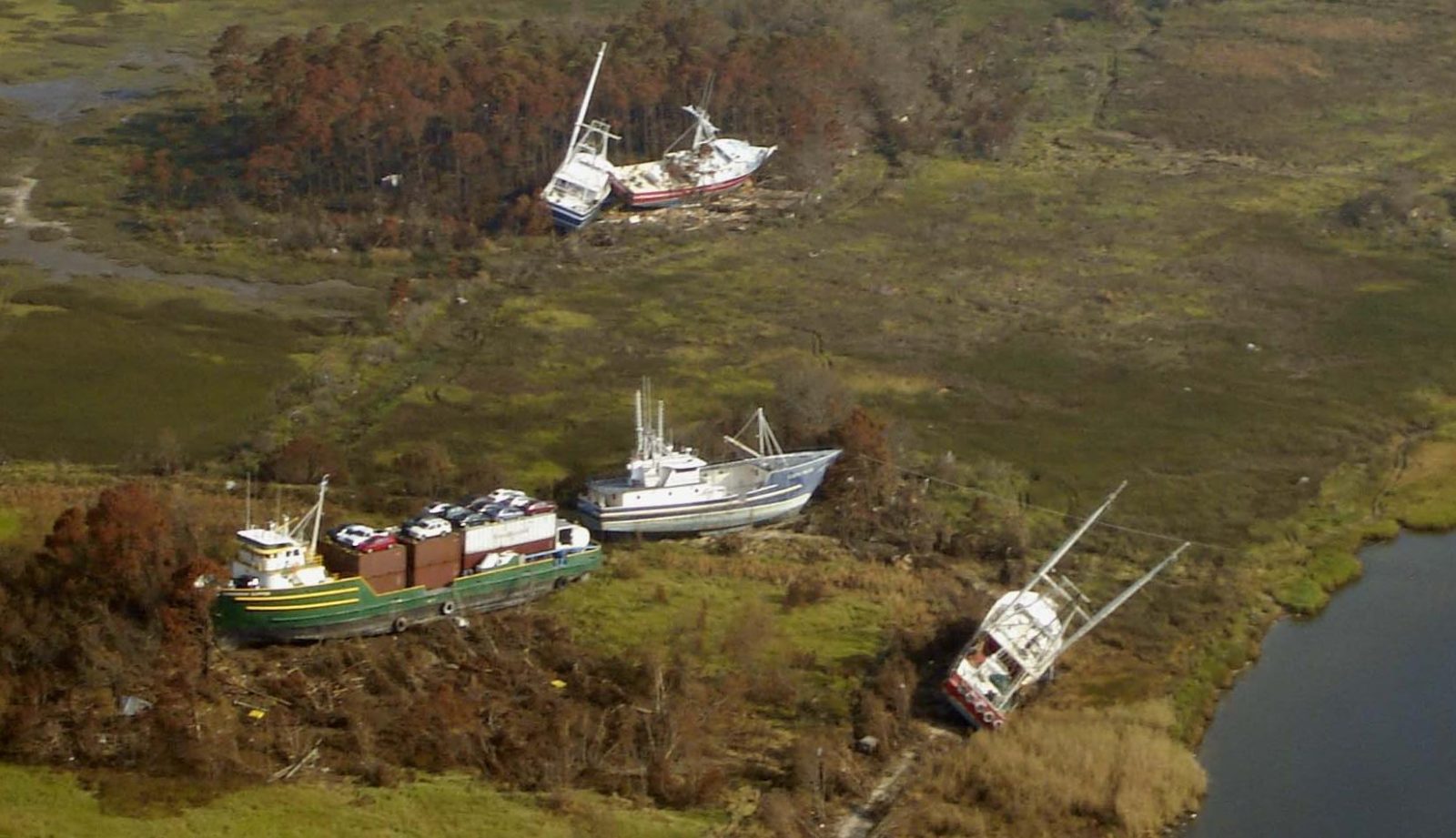
Direct answer: Storm surge is the abnormal rise of water generated by a storm's winds (NWS/NHC). It is historically the leading cause of hurricane-related deaths in the United States — more than wind. A peer-reviewed NHC study found about 49% of US tropical-cyclone deaths from 1963 to 2012 were caused by storm surge; roughly 90% of all such deaths were water-related, versus about 8% from wind (Rappaport 2014). If you live anywhere near the coast, know your evacuation zone today, and leave immediately when local officials order an evacuation.
What storm surge actually is
Storm surge is an abnormal water-level rise generated by a storm, over and above the predicted astronomical tide (NHC). It is the water itself being pushed ashore: a hurricane's strong onshore winds drive a vertical ocean circulation that is disrupted by the shallow ocean bottom near the coast, forcing water upward and inland. The storm tide is the combination of the surge and the normal tide — neither definition includes the waves riding on top, which can add additional feet. Storm tides can reach 20 feet or more when the surge arrives at high tide (NHC).
It helps to respect what that water weighs: roughly 1,700 pounds per cubic yard. That mass lets battering waves reach far inland and can undermine the foundations of buildings that survived the wind (NHC).
The deadliest part of the hurricane
About half of US tropical-cyclone deaths between 1963 and 2012 came from storm surge, with another 27% from rainfall flooding and mudslides — about 90% water-related in total, versus around 8% from wind (Rappaport 2014). Hurricane Katrina's surge is the textbook case: although Katrina weakened to a Category 3 before landfall, its enormous size pushed a maximum observed surge of 27.8 feet at Pass Christian, Mississippi, with 17 to 22 feet along the eastern half of the Mississippi coast (NHC Tropical Cyclone Report, updated January 2023). The report's revised toll is 1,392 fatalities — 520 direct — and notes that the vast majority of the Mississippi deaths were probably caused directly by the surge.
More recently, Hurricane Helene made landfall in Florida's Big Bend as a Category 4 and pushed peak surge inundation of 12 to 16 feet above ground level from west of Keaton Beach through Steinhatchee, with a 16.1-foot high-water mark recorded inside a Steinhatchee condominium — on its second story (NHC). Helene caused at least 250 US fatalities, including 14 direct storm-surge deaths, all in Florida. The NHC's surge page also notes that Hurricane Ian's (2022) surge impacts cost 41 lives — a reminder of the devastation surge causes.
It is not just a beach problem
Surge can travel several miles inland, especially along bays, rivers and estuaries, and even up rivers and canals (NWS/NHC). The NHC's National Storm Surge Risk Maps, it says, "make it clear that storm surge is not just a beachfront problem," with surge risk extending many miles inland in some areas. All locations along the US East and Gulf coasts are vulnerable (NHC).
How high the surge gets depends on more than the storm's category: intensity, forward speed, size, angle of approach and coastline shape all matter. Katrina was "only" a Category 3 at landfall but remained exceptionally large — hurricane-force winds reached at least 75 nautical miles east of its centre — and the surge was amplified by waves set up while it was a Category 4–5 offshore (NHC). A wide, gently sloping continental shelf, like the Louisiana/Mississippi Gulf Coast, allows higher surge; concave coastlines like Apalachee Bay, Florida, focus it (NHC).
Warnings and official surge maps
When a tropical cyclone threatens, the NHC issues a Storm Surge Watch when life-threatening inundation is possible, generally within 48 hours, and a Storm Surge Warning when there is a danger of life-threatening inundation, generally within 36 hours. With advisories, the NHC publishes two inundation products: the Potential Storm Surge Flooding Map — a reasonable worst-case scenario showing where water could rise above ground — and the Peak Storm Surge Forecast Graphic (NHC).
Before any storm exists, check the NHC's National Storm Surge Risk Maps: SLOSH-model worst-case scenarios for Category 1–5 hurricanes that show who is vulnerable. The NHC's advice is blunt: if those maps show you in a vulnerable area, find out whether you are in a storm-surge evacuation zone through your local emergency management agency, and decide where you will go and how you will get there.
How to stay safe
Know your evacuation zone. Learn your routes, practise them with your household and pets, and identify where you will stay — then follow local emergency managers' instructions. If you live in a mandatory evacuation zone and officials tell you to evacuate, do so immediately (ready.gov).
If you are trapped by flooding, go to the highest level of the building — but do NOT climb into a closed attic, where rising water can trap you (ready.gov). And never walk, swim or drive through floodwater: six inches of fast-moving water can knock you down, and a foot of moving water can sweep your vehicle away — the NWS's "Turn Around, Don't Drown" rule (ready.gov).
Have several ways to receive alerts: the FEMA app for real-time NWS alerts, community alert systems, and the Emergency Alert System (ready.gov).
Related pages on this site: the Storm Surge Safety Guide, the Tropical Outlook, US weather alerts by state, and the historical disaster archive.
Frequently asked questions
What is the difference between storm surge and storm tide?
Storm surge is the abnormal rise of water generated by a storm's winds, over and above the predicted astronomical tide (NHC/NWS). The storm tide is the combination of the storm surge and the normal astronomical tide. Neither includes the waves on top of the surge, which can add additional feet (NHC).
How high can storm surge get?
Hurricane Katrina pushed a maximum observed surge of 27.8 feet at Pass Christian, Mississippi, with 17 to 22 feet along the eastern half of the Mississippi coast (NHC). Hurricane Helene pushed 12 to 16 feet above ground level in Florida's Big Bend. Storm tides can reach 20 feet or more when surge coincides with normal high tide (NHC).
What is the difference between a Storm Surge Watch and a Storm Surge Warning?
A Storm Surge Watch means life-threatening inundation is possible, generally within 48 hours. A Storm Surge Warning means there is a danger of life-threatening inundation, generally within 36 hours (NHC). In both cases, promptly follow evacuation orders from local emergency management officials.
Can storm surge reach me if I do not live on the beach?
Yes. Storm surge can travel several miles inland, especially along bays, rivers and estuaries, and even up rivers and canals (NWS/NHC). The NHC's National Storm Surge Risk Maps show surge risk extending many miles inland in some areas — it is not just a beachfront problem.
Sources
- NHC - Storm Surge Overview
- NHC - Storm Surge Products (Watch/Warning definitions, flooding maps)
- NHC - National Storm Surge Risk Maps
- NHC - Tropical Cyclone Report: Hurricane Katrina (updated Jan 2023)
- NHC - Tropical Cyclone Report: Hurricane Helene (AL092024)
- NWS - Hurricane Safety Tips and Resources
- Ready.gov - Hurricanes
- Rappaport 2014 - Fatalities in the US from Atlantic Tropical Cyclones (BAMS)
About the author
WND Editorial Team — The World Natural Disasters editorial team curates disaster information from official scientific and humanitarian sources, reviews safety guidance against public-agency recommendations, and maintains the historical database.
Written and reviewed under our editorial policy. Factual claims cite the sources listed above.
Found an error? See our corrections policy.