Hail Safety: What to Do When Ice Falls From the Sky
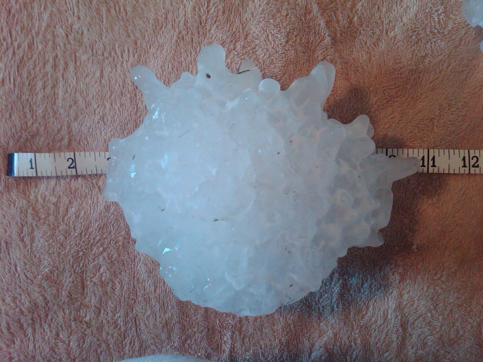
Direct answer: Hail is the one frozen weather hazard that can hit you in the middle of a summer heatwave. In a strong thunderstorm, powerful updrafts carry raindrops high into freezing air, where they collect layer after layer of ice until they are too heavy to stay aloft. Stones larger than 4 inches can fall faster than 100 mph — hard enough to kill. The National Weather Service's safety rule is simple: get inside, put as many walls between you and the outside as you can, and stay away from windows.
How hail forms
Hail is a hallmark of strong thunderstorms. Updrafts inside the storm lift raindrops into the coldest upper reaches of the cloud, where they freeze. The growing stone then falls partway, gathers more water, and is swept back upward to freeze again — the layered, onion-like structure of a cut hailstone records those trips. The process repeats until the stone is heavier than the updraft can support, and then it falls to the ground. NOAA's National Severe Storms Laboratory notes that high in the storm the air is below -40°F, so hailstones need liquid water in the middle levels to keep growing.
The stronger the updraft, the bigger the stone. According to the National Weather Service's reference scale, pea-sized hail is 1/4 inch across, quarter-sized hail is 1 inch — and quarter-size or larger counts as severe. Golf balls are 1 3/4 inches, tennis balls 2 1/2 inches, baseballs 2 3/4 inches, softballs 4 inches. The largest hailstone recovered in the United States fell in Vivian, South Dakota: 8 inches across with an 18.62-inch circumference, weighing 1 pound 15 ounces.
Why it is so dangerous
Size is only half the story; speed is the other half. NSSL research finds small hailstones under an inch fall at 9 to 25 mph, 1 to 1.75-inch stones at 25 to 40 mph, 2 to 4-inch stones at 44 to 72 mph — and stones over 4 inches can exceed 100 mph. If surface winds are strong, hail can fall at an angle or even nearly sideways, and wind-driven hail can tear siding off houses, break windows, smash car side windows, and cause severe injury or death to people and animals outdoors. Only the very largest stones pose a serious risk to people in the open, but hailstorms deliver a mix of sizes, and only a ruler or tape measure — not a guess — settles how big the biggest ones were.
Hail can also turn roads lethal without a drop of rain. NSSL reports storms that produced hail drifts several feet deep in clogged drainage channels, and a roadway completely covered in hail behaves exactly like an icy road: if the layer is deep enough, a vehicle's tires may not touch the pavement at all.
What to do before the storm
Learn the alert language: a Severe Thunderstorm Watch means conditions are favorable for severe thunderstorms to develop; a Warning means one is occurring or imminent in your county. Keep a way to get weather alerts on your phone and a NOAA Weather Radio with fresh batteries. Before a storm arrives, move vehicles into a garage or under a carport if time and safety permit, secure loose outdoor items, and bring in pets. Think ahead about which small interior room on the lowest floor of your home, school or workplace you would go to — an interior closet or bathroom is ideal.
What to do during the storm
When severe thunderstorms threaten, go to that small interior room on the lowest floor and avoid windows. The National Weather Service's rule of thumb: put as many walls between you and the outside wind as possible. Remember that tornadoes can spin up inside the same storms — if one approaches, get into an interior closet or bathroom and shield your head and body with something padded, like pillows or a mattress.
If you are driving when hail starts: avoid driving through severe thunderstorms; pull over or delay travel. If you must stop, pull off the road if possible and point the vehicle into the wind — the windshield is the strongest window — then cover yourself with a jacket or floor mat in case glass shatters. And one firm rule from the National Weather Service: do not park under overpasses. A line of stopped cars under an overpass blocks traffic, including for emergency vehicles.
If you are caught outdoors with no shelter, get low in a ditch or depression away from hills, water, lone tall trees and power poles, and protect your head and neck with your arms or anything you are carrying.
After the storm
Stay inside until the storm has fully passed — hail can return in a second wave. Drive only if you must, and slowly: hail-covered roads are ice roads. Photograph damage with a ruler next to the largest stones for insurance reports, and watch for the secondary hazards the same storm system brings: flooding, downed power lines and lightning. See our Severe Cold & Winter Storm Safety for the opposite ice hazard, the US weather alerts by state for warnings in force now, and the historical disaster archive for what these storms have done before.
Frequently asked questions
What is the difference between a Severe Thunderstorm Watch and a Warning?
A Watch means conditions are favorable for severe thunderstorms to develop; a Warning means a severe thunderstorm is occurring or imminent in your county. When a Warning is issued, take shelter immediately.
How fast can hail fall?
It depends on size. NOAA's storm laboratory finds small hail falls at 9 to 25 mph, 1 to 1.75-inch stones at 25 to 40 mph, 2 to 4-inch stones at 44 to 72 mph, and stones over 4 inches can fall faster than 100 mph.
Should I park under an overpass during a hailstorm?
No. The National Weather Service warns against it: stopped cars under overpasses block traffic, including for emergency vehicles. Pull off the road if possible, point into the wind, and cover yourself.
Can hail damage roads?
Yes — a roadway completely covered in hail behaves like an icy road. NOAA notes that if the layer is deep enough, tires may not touch the pavement at all, and hail drifts can pile several feet deep in drainage channels.
Sources
- NOAA National Severe Storms Laboratory - Severe Weather 101: Hail Basics
- National Weather Service - Hail Safety Rules
- National Weather Service - Severe Weather Preparedness
About the author
WND Editorial Team — The World Natural Disasters editorial team curates disaster information from official scientific and humanitarian sources, reviews safety guidance against public-agency recommendations, and maintains the historical database.
Written and reviewed under our editorial policy. Factual claims cite the sources listed above.
Found an error? See our corrections policy.