El Niño Winter 2026–27: What It Means for Snow, Rain and Cold
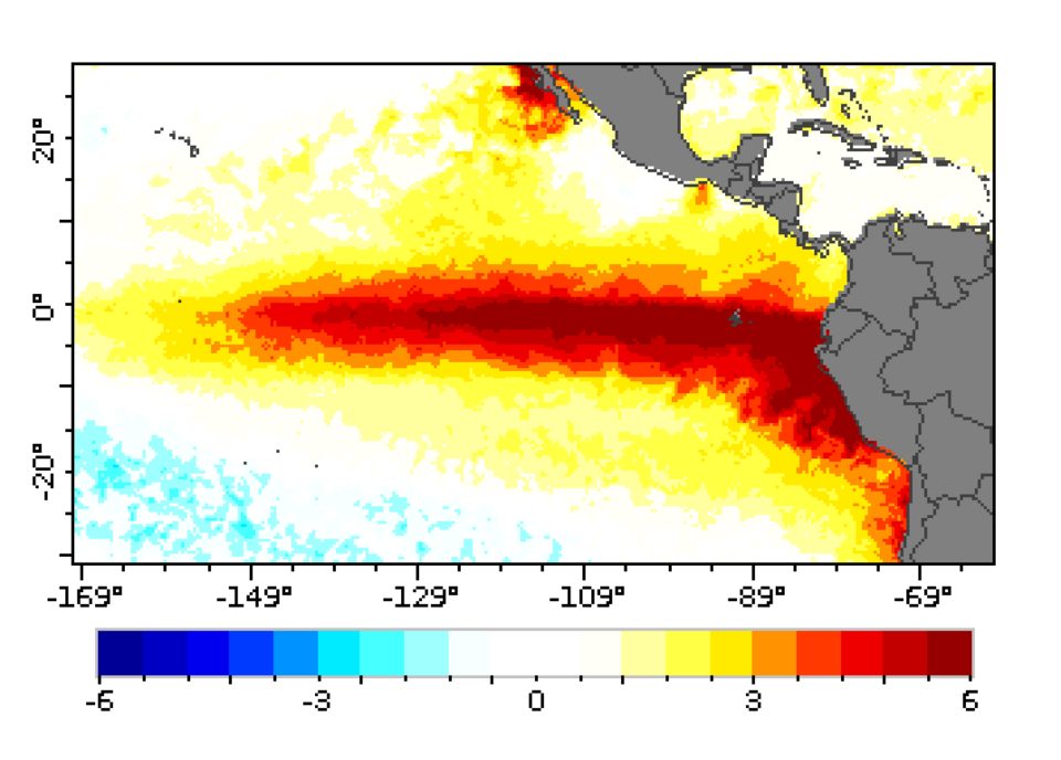
Direct answer: A very strong El Niño is shaping the winter of 2026–27. On 12 November 2026 the Climate Prediction Center said the equatorial Pacific was 2.5°C warmer than average in the key Niño-3.4 region, and gave a greater than 79% chance that a strong to very strong El Niño lasts through January to March 2027. NOAA's winter outlook, published on 15 October, favours warmer-than-average weather across much of the northern United States and wetter weather across the south and the East Coast. That is the shape of the season — not a promise for any single week.
What El Niño actually is
El Niño is a shift in the tropical Pacific that happens every two to seven years. The trade winds that normally push warm surface water west weaken, and the warm water slumps back toward South America. That moves the jet streams, and the storm tracks that follow them. In 2026 the warm pool is unusually strong: the Niño-3.4 region measured 2.5°C above average, Niño-3 was 3.6°C above average, and Niño-1+2, right against the South American coast, was 4.4°C above average. The Climate Prediction Center put the chance of an event that beats every one since 1950 at about 60%. The Met Office has called it the largest "in living memory" and an "unprecedented event". The last very strong El Niño was 2015–16, and this is the first El Niño since the moderate event of 2023–24.
What NOAA expects this winter
Warmer-than-average conditions are favoured for northern California, the Pacific Northwest, the Midwest, the Mississippi Valley, much of the East and Alaska. The south-east, including Florida, leans near normal. In strong El Niño winters, a majority of seasons at La Crosse and Rochester in the Upper Midwest fell in the warmest third of the record.
Wetter-than-average conditions are favoured across the southern tier of the country and the East Coast. The northern Mountain West and parts of the Great Lakes lean drier. NOAA expects drought to ease or improve in the Southwest, the southern Plains, the South-east and the East Coast.
Strong El Niño winters usually mean less snow than average in the places the National Weather Service offices in La Crosse and Rochester studied — seven of the nine seasonal snow totals there were below normal, with the other two near normal. But the same records show that individual months can still be among the snowiest on record: four of those nine winters had a month in the top ten snowiest. A warm outlook does not switch off winter.
The UK and Europe angle
Across the Atlantic, the Met Office says El Niño is likely to increase the chances of wetter, stormier conditions in north-west Europe during autumn and the early part of winter. Its outlook for November to January puts a wet winter at about a two-in-five chance, roughly double the usual one-in-five, and says a wet winter is now much more likely than a dry one, which sits at about one-in-ten. Effects on Europe often lag, and later in the winter there is a slightly increased risk of cold spells. The World Meteorological Organization says the event is firmly established and very likely to persist until February 2027. El Niño also nudges global temperatures up: most events add about 0.2°C.
What it does not mean
A seasonal outlook is a set of odds, not a forecast for any day. A warm winter can still hold a brutal cold snap, and a snowy month can still fall inside a below-average season. El Niño is only one influence on the winter: the outlook also weighs the phase of the quasi-biennial oscillation, a regular swing in stratospheric winds, and local geography — mountains, lakes and coasts — still decides what falls on your street.
The La Crosse and Rochester outlook notes that a westerly phase of the quasi-biennial oscillation makes a sudden stratospheric warming less likely this winter. Such warmings can collapse the polar vortex and flood the United States with Arctic air, so fewer of them means fewer Arctic outbreaks. But fewer does not mean none. And a single storm does not prove or disprove the outlook. Judge the season in April, not in January.
How to use the outlook
Treat the outlook as a nudge, not a plan. If you live in the northern tier, a warmer-than-average season is no reason to skip winter tyres or leave the pipes unlagged — the cold still arrives, just less often. If you live in the south or along the East Coast, a wetter season means checking gutters, drains and flood cover before the rain does. And wherever you live, a seasonal outlook never replaces the short-range forecast. Check our weather alerts page before you travel, and read our cold safety guide — the outlook sets the odds, but the forecast tells you what to do tomorrow.
Frequently asked questions
Is this the strongest El Niño ever?
Not yet — that is a forecast, not an observation. The Climate Prediction Center gives about a 60% chance that it beats every El Niño since 1950. The Met Office has called it the largest "in living memory" and an "unprecedented event". We will only know the final ranking when the event ends.
Will it be a warm winter where I live?
It depends where you live. Warmer-than-average weather is favoured across the northern United States, the Midwest and much of the East; the south-east leans near normal. The outlook gives odds for a whole season, not a temperature for any given week.
Does a warm winter mean no snow?
No. In the nine strong El Niño winters the La Crosse and Rochester offices studied, seven seasonal snow totals were below normal — but four of those winters still had a month in the top ten snowiest. Snowstorms still happen in warm winters.
What does El Niño mean for the UK?
Wetter, stormier conditions are more likely in north-west Europe in autumn and early winter. The Met Office puts a wet winter for November to January at about a two-in-five chance, double the usual odds. Later in winter, cold spells become slightly more likely.
Sources
- NOAA Climate Prediction Center - ENSO Diagnostic Discussion, 12 November 2026
- National Weather Service La Crosse - Winter 2026-27 Outlook, 15 October 2026
- House of Commons Library - El Niño 2026-27
About the author
WND Editorial Team — The World Natural Disasters editorial team curates disaster information from official scientific and humanitarian sources, reviews safety guidance against public-agency recommendations, and maintains the historical database.
Written and reviewed under our editorial policy. Factual claims cite the sources listed above.
Found an error? See our corrections policy.