Bomb Cyclones: When Winter Storms Explode in Strength
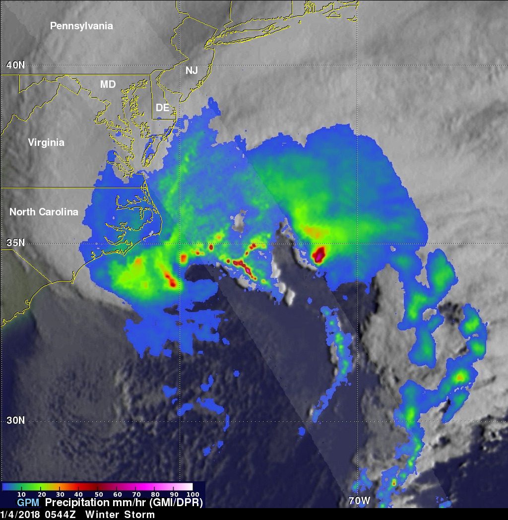
Direct answer: A bomb cyclone is a midlatitude winter storm that strengthens explosively. Meteorologists call the process bombogenesis: it happens when a midlatitude cyclone rapidly intensifies over a 24-hour period, measured by a drop in its central pressure. At 60 degrees latitude, the pressure must fall at least 24 millibars (24 hectopascals) in 24 hours; at the latitude of New York City, the required drop is about 17.8 millibars in 24 hours. That is the definition used by NOAA's National Ocean Service. The word “bomb” refers to the speed of the pressure fall, not to any explosion.
How a bomb cyclone forms
Bombogenesis happens when a cold air mass collides with a warm air mass, such as air over warm ocean waters, according to NOAA. The sharp temperature contrast along the coast, plus energy from a strong jet stream disturbance, lets the storm's central pressure plunge. As the pressure falls, the winds spinning around the low strengthen, much like a hurricane's winds strengthen as its pressure falls, and the storm pulls colder air in behind it. On satellite imagery, these storms often show a classic comma-shaped precipitation shield, with the heaviest precipitation wrapped around the storm's centre.
Why they are dangerous
A bomb cyclone is not a category or a severity rating; it is a measure of how fast a storm strengthens. But a rapidly deepening storm can bring the full range of winter hazards at once: heavy snow, strong winds, blizzard conditions and coastal flooding. The National Weather Service notes that blizzards bring strong wind, blowing snow and whiteout conditions that make roads impassable, and that thousands of people are injured or killed every year in traffic accidents related to slippery roads from winter storms. A bomb cyclone's winds can reach hurricane force: when Winter Storm Grayson was bombing out off the East Coast in January 2018, it was expected to bring hurricane-force winds to parts of New England, along with extreme wind chills.
The January 2018 example
Winter Storm Grayson is a textbook case. NASA's Global Precipitation Measurement mission recorded the storm on 4 January 2018 as its surface low passed off Cape Hatteras, North Carolina. At that time, the National Weather Service analyzed Grayson's central pressure at 972 millibars, on par with a Category 1 hurricane and already 32 millibars deeper than it had been just 12 hours earlier, which already qualified it as a bomb. The storm went on to bring snow, freezing rain, high winds and blizzard conditions from Florida to Maine. Closer to home for this week's history entry, the Great Blizzard of 1978 was also a bombogenesis event: the National Weather Service office in Detroit records that its central pressure fell 40 millibars in 24 hours.
Is a bomb cyclone a hurricane?
No. A hurricane is a tropical cyclone, born over warm tropical oceans. A bomb cyclone is a midlatitude cyclone, born where cold and warm air masses collide, usually in fall and winter. The two can have similar central pressures and similar wind speeds, which is why Grayson's 972-millibar pressure drew the hurricane comparison, but they are different kinds of storm. What matters for safety is not the label but the hazards: snow, wind, ice and surge arriving together, and often faster than expected.
What to do when one is forecast
Treat a bomb cyclone forecast like any major winter storm forecast, but take the speed of change seriously: conditions can go from fair to whiteout in hours. The National Weather Service's travel advice is blunt: the best way to prevent treacherous winter travel is to avoid it, by staying informed about current weather and road conditions and the latest forecasts. Check warnings on our weather alerts page before you set out, and if a warning covers your route, delay travel until the storm passes. If you are caught out and become stranded, stay with your vehicle, run the motor about ten minutes every hour for warmth, keep a window open a little to prevent carbon monoxide buildup, and keep the exhaust pipe clear of snow. For the wider winter plan, read our severe cold and winter storm safety guide.
Frequently asked questions
What is bombogenesis?
The rapid intensification of a midlatitude cyclone over 24 hours, measured by a fall in central pressure. At 60 degrees latitude the fall must be at least 24 millibars in 24 hours; the threshold is lower at lower latitudes, about 17.8 millibars near New York City.
Is a bomb cyclone a hurricane?
No. A hurricane is a tropical cyclone formed over warm tropical oceans. A bomb cyclone is a midlatitude cyclone formed where cold and warm air masses collide. They can reach similar pressures and wind speeds, but they are different kinds of storm.
Why is a bomb cyclone dangerous?
Because it strengthens so fast, it can deliver heavy snow, strong winds, blizzard whiteouts and coastal flooding together, often faster than expected. The National Weather Service notes that blizzard whiteouts make roads impassable and that slippery winter roads injure or kill thousands of people in traffic accidents every year.
What should I do if a bomb cyclone is forecast for my area?
Stay informed on forecasts and warnings, and avoid travel if a warning covers your route — the National Weather Service calls avoiding treacherous travel the best prevention. If you become stranded, stay with your vehicle, run the motor about ten minutes an hour, keep a window cracked open, and keep the exhaust pipe clear.
Sources
- NOAA National Ocean Service - What is Bombogenesis?
- NASA GPM - GPM Sees Powerful Winter Storm Grayson
- National Weather Service - Winter Safety
- National Weather Service Boulder - Winter Travel Safety
About the author
WND Editorial Team — The World Natural Disasters editorial team curates disaster information from official scientific and humanitarian sources, reviews safety guidance against public-agency recommendations, and maintains the historical database.
Written and reviewed under our editorial policy. Factual claims cite the sources listed above.
Found an error? See our corrections policy.