Satellite before and after
Sakha (Yakutia) wildfires 2021: Siberia's record fire season
Fires broke out in Sakha as soon as the snow began melting in May 2021 and burned through the summer, in the region's most severe fire season in decades.
The larch forests around Yakutsk and the Lena River, Republic of Sakha, Russia · May to September 2021 · Wildfire · Russia
Compare the imagery
Drag the divider, or focus it and use the arrow keys. Left of the divider is 10 Jun 2021, right is 1 Sep 2021, 83 days apart.
The interactive comparison needs JavaScript. Both images are shown below.
Some imagery tiles did not load. NASA's service may be busy; the two full images below are the same pictures.
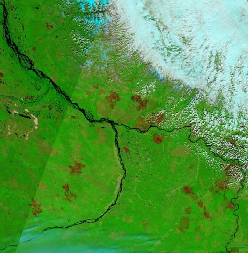
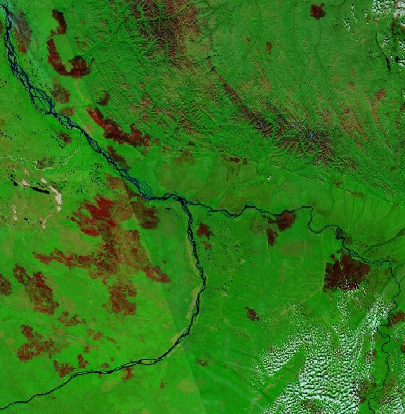
In this false-colour view water is dark blue to black, vegetation is bright green, bare ground is tan, freshly burned land is red-brown and cloud is cyan.
The two images
What the images show
On 10 June smaller red-brown scars — from earlier years, or from fires burning since May — are already scattered through the forest. On 1 September large burn scars, many of them dozens of kilometres long, lie on both sides of the Lena River.
About the event
- NASA Earth Observatory reported that more than 8.4 million hectares of forest burned in Sakha in 2021, more than in any year since MODIS on the Terra satellite began collecting data in 2000.
Limits of this comparison
The before-image is not a fire-free baseline: fires had been burning since May. It is from Terra and the after-image from Aqua. Cloud covers the north-east of the 10 June image. This box is a small part of the area that burned.
Each image is one satellite pass at about 250 metres a pixel. It shows where water or burned land is visible from space on that day; it does not measure damage, and cloud or haze can hide what is underneath.
Dates were chosen by checking the imagery on both satellites for several days either side and keeping the clearest pass; the two images come from different satellites carrying the same instrument. Both use the same layer, MODIS Corrected Reflectance, bands 7-2-1.
Sources
- NASA Earth Observatory — A Record-Breaking Year for Fire in Sakha
- Imagery: NASA Global Imagery Browse Services (GIBS), MODIS on the Terra and Aqua satellites — GIBS documentation
We acknowledge the use of imagery provided by services from NASA's Global Imagery Browse Services (GIBS), part of NASA's Earth Science Data and Information System (ESDIS). Comparison slider: leaflet-side-by-side (MIT licence). Case last updated 13 Sep 2026.
Questions
What does the satellite image of The larch forests around Yakutsk and the Lena River, Republic of Sakha, Russia show?
On 10 June smaller red-brown scars — from earlier years, or from fires burning since May — are already scattered through the forest. On 1 September large burn scars, many of them dozens of kilometres long, lie on both sides of the Lena River.
When were the two satellite images taken?
The before-image was taken by Terra, 10 Jun 2021 and the after-image by Aqua, 1 Sep 2021, 83 days apart.
What can this before-and-after comparison not show?
The before-image is not a fire-free baseline: fires had been burning since May. It is from Terra and the after-image from Aqua. Cloud covers the north-east of the 10 June image. This box is a small part of the area that burned. Each image is one satellite pass at about 250 metres a pixel. It shows where water or burned land is visible from space on that day; it does not measure damage, and cloud or haze can hide what is underneath.
Related
- Natural disasters in Russia, live and recent
- Current wildfire events worldwide
- Before and after: 2022 Pakistan floods: the Indus plain in Sindh
- Before and after: Storm Daniel 2023: floods on the Thessaly plain, Greece
- Before and after: Cyclone Idai 2019: flooding inland from Beira, Mozambique
- Before and after: Rio Grande do Sul floods 2024: Porto Alegre and the Patos Lagoon, Brazil
- Before and after: Black Summer bushfires: Kangaroo Island, Australia, 2019–20
- Before and after: 2010 Pakistan floods: the Indus around Sukkur and Jacobabad
- Before and after: Sudan 2020: the Nile in flood at Khartoum
- Before and after: Hurricane Harvey 2017: floods across the Texas coastal plain
- Before and after: Missouri River floods 2019: Nebraska and Iowa
- Before and after: Nigeria floods 2022: the Niger and Benue at Lokoja
- Before and after: Quebec wildfires 2023: burn scars in the boreal forest
- Before and after: Jasper wildfire 2024: the burn scar in Jasper National Park
- Before and after: Evia wildfires 2021: northern Evia, Greece
- Before and after: Pantanal fires 2020: the northern Pantanal, Brazil
- Before and after: Camp Fire 2018: Paradise, California
- Before and after: Manavgat fires 2021: Türkiye's Mediterranean coast
- Before and after: Eastern Australia floods 2022: Lismore and the Northern Rivers, New South Wales