Severe Flood ● Monitoring
Flooding is expected: South Hayling and South Eastoke seafront, United Kingdom of Great Britain and Northern Ireland
Loading live data… · Marker positions are approximate; severity is labelled in each popup. Sources: USGS, GDACS, NASA EONET, NOAA/NWS, EMSC.
High tides are expected to cause flooding over the next two days.
Flooding is expected for 2 hours either side of Monday evening's tide at 23:18 on 26/10/2026
The weather increases tide table values by 0.15 m. The total forecast tide is 5.03 metres Chart Datum (2.30 mAOD) at Portsmouth. Strong Southerly Force 6 wind. South Hayling beach (towards Eastoke) has been affected by previous storms. Water could push further up the beach than normal. Property at Eastoke corner, near the nature reserve, and at Southwood Road may flood. Overtopping of splash walls along the beach front may flood gardens. Beach huts at West Beach, near the Inn on the beach may also be affected.
Tuesday's tide at 11:40 27/10/2026 is forecast to be 7 cm lower (2.23 mAOD).
We are liaising with emergency services and local authorities .
Activate any flood protection products you may have. Avoid South Hayling seafront. Shingle can be thrown by wind and waves.
This message will be updated by 4:00PM on Tuesday 27 October or as the situation changes.
Measurements
| Coordinates | 50.7826, -0.9616 |
|---|---|
| Region | South Hayling and South Eastoke seafront |
| Location Precision | polygon |
| Issuing Authority | United Kingdom of Great Britain and Northern Ireland — uk-metoffice-en |
| Cap Urgency | Immediate |
| Cap Certainty | Likely |
| Cap Expires | 2026-11-05T15:20:25+00:00 |
Official source
Warnings courtesy of the issuing national meteorological service, via the WMO Alert Hub.
This is an official warning issued by the authority named above. Follow its instructions and those of your local emergency services.
Severity as published by WMO Alert Hub (national weather services).
View original reportThis event as JSON · API and licence
Source updated 7 days ago (Oct 26, 2026 15:29 UTC) · we last heard from WMO Alert Hub (national weather services) 56 seconds ago
On a slow connection? Low-bandwidth version — no map, no scripts, under 14 KB.
Satellite view, before and after
The latest clear Sentinel-2 pass before this event and the earliest one after it.
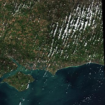
17 Oct 2026, 9 days before this event. 3.5% cloud across the tile.
No clear pass yet. Sentinel-2 revisits every few days and cloud can hide a place for longer — this event is 7 days old, and a clear scene will appear here once one exists.
The white ring marks where the event was reported.
Each image is a preview of a whole Sentinel-2 tile — an area of roughly 110 by 110 km, where one pixel is about 320 metres — not a close-up of the event, which may be a small part of it. "Clear" means under 30% cloud across the entire tile, so the exact place that matters can still be hidden. These are pictures for context, not an assessment of damage.
Contains modified Copernicus Sentinel data 2026, found through the Earth Search catalogue (Element 84) and served from the AWS Open Data Sentinel-2 archive.
What GloFAS forecasts for the rivers nearby
No chance of exceeding even its 2-year flood flow in this forecast.
GloFAS alert level: Inactive · Peak expected: in 11-14 days (on 2026-11-13) · forecast of 2 Nov 2026
GloFAS forecasts are computer model output, published for information only. They are not a flood warning: only national and regional authorities issue flood warnings for their own area. A reporting point is a place on the model's river network, which may sit a few kilometres from the town it is named after. All rivers →
Official authorities in United Kingdom
If you are there, these are the bodies whose instructions apply. This site is not an emergency service and does not issue warnings.
More for United Kingdom →What to do
Follow the instructions issued by WMO Alert Hub (national weather services) and your local emergency services. The guidance below is background.
Flood preparation, evacuation decisions, and the dangers of driving or walking through floodwater.
Open Flood Safety Guide →Earlier flood events in United Kingdom
Severe and extreme events of the same kind, before this one. Listed for scale, not because they are connected to it.
Nearby & related events
Disclaimer: figures are automatic feeds from the named agencies and may be revised. Do not use this page for life-safety decisions — follow official local emergency services.