Severe Flood ● Monitoring
Flood Warning issued October 16 at 10:44AM EDT by NWS Melbourne FL, United States of America
Loading live data… · Marker positions are approximate; severity is labelled in each popup. Sources: USGS, GDACS, NASA EONET, NOAA/NWS, EMSC.
...The Flood Warning continues for the following rivers in Florida...
St Johns River Near Astor affecting Volusia and Lake Counties.
.The St Johns River at Astor is forecast to remain in Minor Flood
Stage through Saturday, as previous heavy rainfall continues to drain
through the basin. Strong northeasterly winds this weekend will slow
or even reverse flow, causing the river to rise back into Moderate
Flood Stage, with a steady increase through Moderate Flood Stage
forecast through early next week.
For the St. Johns River...including Astor...Moderate flooding is
forecast.
* WHAT...Minor flooding is occurring and moderate flooding is
forecast.
* WHERE...St Johns River near Astor.
* WHEN...Until further notice.
* IMPACTS...At 2.8 feet, Docks and boat ramps covered at South Moon
Fish Camp and approaching sea wall at Blair's Jungle Den. Water
approaching sites closest to the river at Fish Tales RV Resort and
Astor Landing Campground. Portion of Clair Street covered by river
water south of the Butler Boat Ramp. Docks underwater at the Astor
Bridge Marina and along Riveredge Drive. Portions of Fox Road are
covered with water nearest to the river. Acorn, Hazelnut and Redbud
roads are underwater with yards inundated. At 3.0 feet, Water
approaches or may enter lowest homes on or near Wildhog Road and
nearby canals. Flooding reaches the parking lot of the Juno Trail
Apartments. Flooding on portions of Alligator Road and Holiday
Road. Lowest lying yards along Blue Creek are flooded. Roads at
Astor Landing Campground and Lake Dexter Boat Ramp begin to flood.
Water enters lower homes closest to the river on McPherson Lane. At
3.5 feet, Canals have overflowed into yards. Homes on or near
Wildhog, Bonnet and Snail roads become inaccessible with several
inches of water inside homes along the river and canals. Docks at
Astor Bridge marina and throughout Astor are completely submerged.
Bartram Rd and Holiday Circle are inaccessible with yards
completely submerged. Clair Street
Measurements
| Coordinates | 29.1860, -81.5360 |
|---|---|
| Region | Lake, FL; Volusia, FL |
| Location Precision | polygon |
| Issuing Authority | United States of America — us-noaa-nws-en |
| Cap Urgency | Immediate |
| Cap Certainty | Observed |
| Cap Expires | 2026-10-17T00:00:00-04:00 |
Official source
Warnings courtesy of the issuing national meteorological service, via the WMO Alert Hub.
This is an official warning issued by the authority named above. Follow its instructions and those of your local emergency services.
Severity as published by WMO Alert Hub (national weather services).
View original reportAlso reported by: NWS
This event as JSON · API and licence
Source updated 3 days ago (Oct 16, 2026 14:45 UTC) · we last heard from WMO Alert Hub (national weather services) 59 seconds ago
On a slow connection? Low-bandwidth version — no map, no scripts, under 14 KB.
Internet connectivity at the time
Internet connectivity in United States dropped 33 hours after this event, and stayed disrupted for about 1 hour.
From 18 Oct 2026 00:00 UTC to 18 Oct 2026 01:00 UTC. Detected by active probing — networks that stopped answering.
Internet outages have many causes — damaged cables, power failures, network maintenance and deliberate shutdowns among them. IODA detects the loss of connectivity and does not attribute it to anything. This is shown because it happened at the same time, not because one caused the other.
Measured by IODA, Georgia Institute of Technology.
Satellite view, before and after
The latest clear Sentinel-2 pass before this event and the earliest one after it.
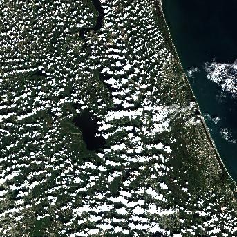
14 Oct 2026, 2 days before this event. 24.7% cloud across the tile.
No clear pass yet. Sentinel-2 revisits every few days and cloud can hide a place for longer — this event is 3 days old, and a clear scene will appear here once one exists.
The white ring marks where the event was reported.
Each image is a preview of a whole Sentinel-2 tile — an area of roughly 110 by 110 km, where one pixel is about 320 metres — not a close-up of the event, which may be a small part of it. "Clear" means under 30% cloud across the entire tile, so the exact place that matters can still be hidden. These are pictures for context, not an assessment of damage.
Contains modified Copernicus Sentinel data 2026, found through the Earth Search catalogue (Element 84) and served from the AWS Open Data Sentinel-2 archive.
Official authorities in United States
If you are there, these are the bodies whose instructions apply. This site is not an emergency service and does not issue warnings.
More for United States →What to do
Follow the instructions issued by WMO Alert Hub (national weather services) and your local emergency services. The guidance below is background.
Flood preparation, evacuation decisions, and the dangers of driving or walking through floodwater.
Open Flood Safety Guide →Earlier flood events in United States
Severe and extreme events of the same kind, before this one. Listed for scale, not because they are connected to it.
Nearby & related events
Disclaimer: figures are automatic feeds from the named agencies and may be revised. Do not use this page for life-safety decisions — follow official local emergency services.